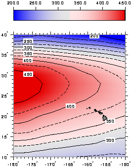
The depth of the 10 C (50 F) isotherm (roughly in the middle of the thermocline) varies markedly, from more than 450 m (1500 ft) northwest of the islands, to less than 240 m (800 ft) to the northeast and southeast (see below).
Variations of temperature result in variations of density, and therefore of weight and pressure of water columns. Ocean currents are set up by such variations of pressure. Owing to the earth rotation, these so-called geostrophic currents follow lines of constant isotherm depth.
The average currents form a large basin-scale clockwise circulation, called gyre, centered at about 28 N. At the latitude of Hawai'i, the circulation is roughly from east to west and intensifies southward. The strength of geostrophic currents decreases with depth, by a factor of two every few hundred meters; below 1000 m (3300 ft), their average is generally less than 5 cm/s (0.1 knot), and their patterns are not entirely known.
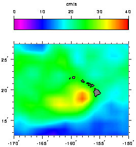
In the surface layer, however, currents driven by the wind combine with geostrophic currents to yield more complicated flow patterns. Surface currents must be measured directly, or computed from the drift of ships or oceanographic buoys (see below). The map of current variability, a measure of how much instantaneous currents would likely depart from the average, indicates that the lee of the islands is populated by vigourous eddies or swirls, which mask the slower average circulation.
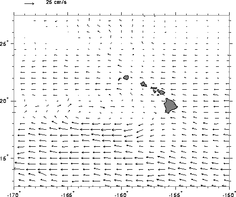
South of Hawai'i, the surface North Equatorial Current (NEC) reaches an average westward speed of 17 cm/s (0.35 knot) at 13 N, and gradually decreases towards the islands. Between 18 N and 22 N, the currents are strongly influenced by the islands. The NEC forks at Hawai'i island; the northern branch becomes the North Hawaiian Ridge Current (NHRC), and intensifies near the islands with a typical width of 100 km (54 NM) and speed of 25 cm/s (0.5 knot). West of the islands, two elongated circulations appear. A clockwise circulation is centered at 19 N, merging to the south with the southern branch of the NEC. A counter-clockwise circulation is centered at 20 30'N. Between them is the narrow Hawaiian Lee Counter Current (HLCC), extending in longitude from 170 W to 158 W. Surface currents over the western islands and north east of the NHRC are variable and their average is smaller than can be estimated from existing data.
The current arrow shown at each grid point is the average of all observations falling within one degree of that point, and is thus the most probable current that one would experience. However, because ocean currents vary in time, freely drifting objects would never follow exactly the flow patterns in Plate 8. The map of current variability, a measure of how much actual currents would likely depart from the average, indicates that the lee of the islands is populated by vigorous eddies or swirls, which obliterate the slower average circulation (see below).